It's going to be way worse than a jumble for the next few years of course, with hundreds of lorry movements, noise, dust, disruption and so on as the shaft for the tunnel is excavated, but eventually the area will be reinstated and Tideway has been consulting with 'local stakeholders' to develop proposals for this work.
The area in question (inside the red dashed lines on the map above) is part of the St Paul's conservation area, which sits in between the Deptford High Street conservation area and the Creekside conservation area.
In case you were wondering what was here before, helpfully there's an old pre-1945 map on the exhibition boards that are downloadable from the consultation page showing the houses that lined Crossfields St before the bombs fell and the post-war clearance took place.
I wasn't able to go to the consultation in the Deptford Lounge when the staff were there, so I only have the information on the boards to go by. I don't know how fluid or fixed the proposals are, what procedures they still have to go through, or even why the boards have put forward three very different options for the space - which in fact suggests that the 'masterplan' is still very much a work in progress.
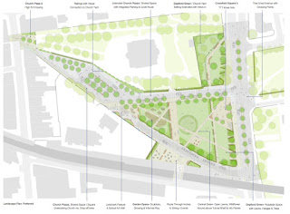
If that's the case, then great. Certain aspects of the 'preferred' masterplan are rather disappointing and I would hope to see them improved.
Inevitably there are certain constraints that can't be eliminated - the need for maintenance access to the tunnel shaft, and the presence of some above-ground infrastructure including ventilation shafts will be a permanent legacy. But this still leaves plenty of flexibility to make usable, pleasant spaces.
First the good stuff. I'm happy to see lots of new trees in the masterplan - let's just hope they make it past the powers that be, and don't have to be eliminated to address 'security' concerns or because they are blocking the vision of the CCTV cameras. The CCTV cameras that are generally worse than useless when it comes to needing evidence of a crime.
I like the trees that are proposed down the middle of Deptford Church Street - it's an awful road at the moment which is way too wide and consequently when it's not blocked by stationary traffic it is abused by speeding traffic, depending on the time of day. Narrower lanes and a tree-lined central reservation, with wider crossing points, would help reduce traffic speeds.
I also like the proposals to open up the views of the church and access to the churchyard, so that it is more welcoming to the community. The rear gate of the churchyard is kept locked these days, which means I rarely go inside the walls - when it was open I regularly strolled through it.
One long-term aspiration for pedestrian links in Deptford has been opening up access through the railway viaduct to Resolution Way and Wavelengths, and that's shown on here with the front of the viaduct proposed as a 'dining and events' space. I assume one of the arches would be opened up on this side to accommodate a cafe/bar premises, although there is probably enough space for a purpose-built premises on the land there.
What I find particularly disappointing is the way in which the central green space is criss-crossed by so many footpaths that its 'green' purpose risks being completely eroded and the space turned from a grassy play area to a network of paths with a few bits of green in between. For a start the long footpath that runs parallel to Crossfields St, right through the middle of the green space, seems redundant - surely people would walk down each side of the green if they were passing through, and planting could be used to encourage that? If they are happy to linger, they won't necessarily want to go in a straight line.
Not only that, retaining highway access and associated parking on both sides of the green space is totally unnecessary in my view. Why not close one side off and claw back more space for greenery and for pedestrians? It seems a retrograde step otherwise.
And how about some greenery at the west end of the street, outside the school? I don't like the fact that it's all been paved rather than greened; seems to suggest that the council has longer term plans for this area than they are willing to admit.
There are lots and lots of trees but they seem entirely undefended from the vagaries of the drivers dropping their kids off at the school or parking to go to church. We've seen on Frankham St how little respect drivers have for trees, and learned that serious protection is needed, so I hope those lessons learned will come into play.
I think there's a real risk of this space becoming 'over engineered' and turned into something that needs too much maintenance and is ornamental rather than useful. I have the distinct impression of the site being divvied up into packages of land each designed and labelled for a specific use rather than any effort being made to create a pleasant space that is adaptable to a range of uses.
I do think there is more potential in the alternative options that are included on the boards, although there's no annotation so I'm having to go by the pictures alone. This one seems a lot less formal and structured, and also retains more green space at the west end of the site although there's still too much space given over to vehicles in my opinion.
If you didn't manage to attend the consultation in the library, you can still give feedback online at the survey page here (but only until next Tuesday 23rd May) or presumably you could also send it to the email address that's given on the consultation page.
As to what the next phase of the process is, either in terms of the procedure or the timescale, again I don't have that information. If anyone knows, please leave a comment and I'll follow up.


