Showing posts with label planning. Show all posts

Friday, 5 January 2018

'Liveable neighbourhood' plans for Deptford Park and environs

Late last year Deptford Folk (the user group for Deptford Park and Folkestone Gardens) got the welcome news that a bid for funding from TfL had been successful. The bid was developed in partnership with Sustrans and proposes a number of improvements to walking and cycling routes in and around the parks - some of them quite substantial projects in their own right.

The money is coming from the 'liveable neighbourhoods' fund and the first tranche will be used to cover the cost of further feasibility studies, with a second slice paid out later for the actual work, presumably depending on the projects being proved feasible - a potential total of £2.9 million for these schemes.


The overall package includes six 'Copenhagen Crossings' (improved road crossings for cyclists and pedestrians) at locations around the parks, and seven more substantial 'interventions' which involve improving existing cycle routes, and creating and opening up new ones, among other things.

One of the flagship 'interventions' which would impact directly on access to Folkestone Gardens is improvement of the existing crossing of Rolt Street, which links the Woodpecker estate (and the pedestrian and cycle route through it) to the gardens.

Although this already exists as a raised crossing, and is on the bend of a road ostensibly with a 20mph speed limit, anyone who uses it will know that this counts for very little. A lot of traffic uses this route as a cut-through, especially in the rush hours, and much of it takes this corner way too fast. There is no refuge or island to slow drivers down, and visibility is poor for anyone coming out of the park, due to the bend in the road and the density of parked cars outside the houses.


Last year Sustrans held a public workshop which involved restricting the road width with some cunningly-arranged straw bales, and inviting school groups and passers by to experience the new road environment and give their feedback on the idea.


During this 'temporary street event' Sustrans also recorded the number and speed of vehicles that passed in both directions - this was collected over a seven day period, 24 hours a day, including the day of the event. Data (which is published in the report here) showed a reduction in traffic speed of around 23% in one direction and 17% in the other at the counter nearest to the restriction. 


I'm curious as to whether this speed reduction would be a permanent outcome of the traffic calming measures that Sustrans is proposing. How much of the speed reduction was down to drivers wondering why there were bales of straw in the road, and kids were prone on the road behind them? Don't speeds just creep back up once drivers get accustomed to new driving conditions? I presume Sustrans has monitored what has happened in other schemes, and I'd be keen to know how it pans out in the long term.

One of the other major projects that the funding will be used to investigate is the plan to create a new cycle route under Evelyn Street, right next to the Blackhorse pub. This route will provide a safe route for cyclists and pedestrians between the parks and estates on the west side of Evelyn Street and the riverside paths and parks of the Pepys estate and Surrey Docks.


It is a collaboration between Deptford Folk, Sustrans, the Ramblers Association, Lewisham Cyclists and Lewisham Council and would create a new route along the line of the former Surrey Canal.

I'm particularly excited about this as when I looked back in the archive I realised I've been banging on about it for seven years now. Seven years! Turns out I've got stamina!

You can read my initial blog post here which includes a photo of the bridge parapet, and a subsequent one here, in which I remarked on improvements to the layout of the buildings proposed for the Wharves development (now the Timberyard) which would make this route a possibility.

It will also build on Deptford Folk's subsequent work which involved objecting against the planning application for the Shurgard storage facility that has just been built at the end of Blackhorse Road. If this application had passed in its original form, the building would have obstructed the proposed route. But Deptford Folk was successful in challenging the application, with the result that the building footprint was moved slightly to leave space for a cycle route on the west side of the road.

With the recent funding award we may at last find out how feasible this idea is, and perhaps even see it brought to fruition in the near future.


More details of the Deptford Folk plans can be seen on the web page here, and if it's something you want to get involved with, they also have an email newsletter you can sign up to, so you'll be kept in the loop. 

Sunday, 29 October 2017

The scandal of Deptford's empty homes and abandoned public realm

When Lewisham Council spends £4 million annually on providing temporary accommodation, and the borough has one of the highest levels of rough sleepers in London, why are newly-built apartments allowed to stand empty?

And why is the council allowing the same developers to wriggle out of their commitments to improve public realm, plant trees and provide disabled parking spaces?


This development on the corner of New Cross Road and Watson's Street has been finished for more than a year now.

The red brick building which faces onto New Cross Road and the smaller, grey/brown bricked block are part of the same development by Kitewood Estates which created a total of 44 new homes; 35 for private ownership and 9 for social rent. The flats for social rent are located in the lower block on Watson's Street, at the end of the development furthest from New Cross Road - the entrance, or 'poor door', to the social housing is in the extreme left of the picture below.


Not a single one of the private flats, which have separate entrances closer to New Cross Road, is occupied; they have lain empty since the block was finished. 

The entrance to the low-rise flats has a sign propped in the window warning that the properties are protected by a security firm; the corridor leading from the street to the flats on the main road still has protective covering on the floor and several notices in the door warning that entry is forbidden and giving a phone number for deliveries.


The casual passer-by might be forgiven for thinking that the blocks are still under construction - the large retail units at street level have been boarded up since being built, and the patchwork of footpath and public realm on Watson's Street is clearly nowhere near finished.

But the social housing is already occupied and the pavement has been like this for months. Surely this is not how it is supposed to be?

Indeed not - the planning application for the block (which was initially refused by Lewisham Council but which was passed at appeal) gives details of the soft landscaping and public realm improvements that the developer was promising.

You can get a clue from the rendering below, although for the full details it's necessary to go to the drawings.


The plans promise six semi-mature trees (five London Plane trees, and one Tulip Tree) and six Witch Hazel shrubs next to the block, to soften its hard edges no doubt. Three mature trees were removed so that the block could be built.


The soft landscaping was even made one of the conditions when the application was given permission at appeal. 

The inspector's report said:
All planting, seeding or turfing comprised in the landscaping scheme hereby approved shall be carried out in the first planting and seeding seasons following the occupation of the buildings, or the completion of the development, whichever is the sooner. Any trees or plants which within a period of 5 years from the completion of the development die, are removed or become seriously damaged or diseased, shall be replaced in the next planting season with others of similar size and species.

As well as soft landscaping, the plans included the creation of four disabled parking bays (the ground floor flats are designed to be accessible for wheelchairs) and a delivery bay, presumably to service the retail units and/or allow parking for refuse collections.

Instead there is a mish-mash of asphalt, a wave of shabby paving stones that hug the edge of the block for dear life, and remnants of the concrete pavement that dates back long before the building work started. If you're walking down here watch your step, especially if you are old or unsteady on your feet - pity the few new residents who have to negotiate it on a daily basis.


When developers fail to deliver on this kind of commitment, and bugger off leaving the job unfinished, it's down to the council's planning enforcement team to sort it out. Officers have the power to investigate breaches and ensure that developers don't get away with cutting corners.

But Lewisham Council's planning enforcement team had other ideas. After the Deptford Society brought it to their attention last year, an 'investigation' was launched.

A copy of the officer's report, which was issued to the Deptford Society last week when they chased the issue up, came into my possession.

The report makes interesting, if jaw-dropping, reading.

Responsibility for enforcing the construction of disabled parking bays was dismissed with the excuse that "if parking is required to make the scheme acceptable then it would have been specified by the planning inspector as a condition for the development".

As for the public realm the comments confirm they couldn't even be arsed to visit the site:
"The aerial photos shows that the soft landscaping scheme has been substantially implemented; to the extent that the aerial photos only show a minor difference to what was approved as part of the appeal decision. The information gathered as part of the desktop study demonstrates that the conditions have been substantially met, and that any breaches of the planning conditions are only minor in nature."


Allowing a public pavement to be left in this state can only be described as negligent - not to mention a personal injury claim waiting to happen. 

And who are the villains in the piece? Which money-grabbing developer is responsible for leaving newly-built flats empty while housing is in such short supply?

Ironically, while the original development was the work of Kitewood Estates and they are most likely responsible for the unfinished state of the public realm, since July 2016 the entire block has been owned by London & Quadrant Housing Trust, bought at a cost of nearly £15 million. 

Friday, 7 July 2017

Consultation on first phase of Convoys Wharf development

Convoys Wharf developer Hutchison Property Group has a public 'consultation' event today and tomorrow (Friday 7th and Saturday 8th July) at the Deptford Methodist Church on Creek Road.

You are invited to attend and give your feedback on the plans for the first detailed planning application for the site, which relates to one plot in the first phase of the work (the one marked in red on the plan below). 


Outline planning permission for the site was granted in 2014 after the developer demanded that the mayor of London call the application in, saying that Lewisham planners were taking too long over it and that they were in a hurry to start work.

Scroll forward three years... 'nuff said. 

You can read my post about the outline application here and there's a lot more background on the development on this blog if you search for 'convoys'. 

The developer's rather woeful website is here.

The consultation is at the methodist church on Creek Road (not Creek Street as the flyer says FFS) from 5-8pm tonight, and 10-1pm Saturday.

Saturday, 10 June 2017

Eight-storey block proposed for New Cross site

A planning application for an eight-storey block of flats in New Cross is threatening to overshadow neighbouring houses and threaten the productivity of one of the area's few allotment sites.

Developers have submitted a planning application to build 26 residential units on a scrap of land sandwiched between the end of Royal Naval Place and the railway line. A block of eight storeys will impact daylight and sunlight to the terraced houses on Amersham Grove as well as blocking out a substantial amount of the sunlight that the allotment site currently enjoys.


The proposed development takes up nearly all the space on the site, representing a gross over-development of the land, in my opinion. The council's (independent) design review panel agrees; original proposals were for much higher blocks which have since been reduced, but the panel noted that even with the changes this represents a very dense use of the site.

A cynic might say that that eight storeys was always the plan. Start high so that you can offer 'concessions' and get down to the height you actually were aiming for. Bargaining is a way of life round here.

Unless you've walked down Amersham Vale from New Cross Station towards the Old Police Station, you've probably no idea where this site is.

At the moment it is used for storing haulage vehicles, and I can't imagine it's pleasant for residents of the small houses opposite having these huge trucks swing in and out of the tiny street every morning and evening. The land could arguably be usefully employed for housing, and its proximity to New Cross station makes it ideal for a car-free residential development.

But the height of the block and density of the development should surely be questioned by planners? Even the housing development planned for Amersham Vale is only five storeys high, and if this proposal ('Hereford Place') is approved, the size and visual impact of the block would be completely out of scale and context in this location.


Residents on Amersham Vale (shown on the right of the picture above) will lose daylight and sunlight to their gardens and properties if this development goes ahead.  Allotment holders are also voicing concerns that their plots will be completely overshadowed by the new building, which is on the west side of the allotments. The waiting lists for Lewisham's few remaining allotment sites are famously long - eight or nine years is the current waiting time apparently. Allowing developments that make plots unviable is surely not a good idea?

In my opinion the council should be making efforts to improve facilities that support healthy lifestyles - growing your own food promotes healthy eating, not to mention the physical exercise and mental health improvements that come from maintaining an allotment. They offer social contact for plot holders and strengthen community links, not to mention creating natural habitats for birds, insects, bees and so on.

Objections and comments can be submitted to planning@lewisham.gov.uk - the planning application is here http://planning.lewisham.gov.uk/online-applications/applicationDetails.do?activeTab=summary&keyVal=_LEWIS_DCAPR_89235

Friday, 9 June 2017

Local consultation on 'Place/Deptford'

Late notice of a rather poorly-publicised consultation event being hosted by Lewisham Council about the proposed construction of a temporary housing site on a corner site of Edward Street/Arklow Road where the disused ball court currently stands.

I wrote about this proposal a couple of months back when it was first announced; tomorrow there will be a public consultation at Charlottenburg Park on Amersham Grove, which is just across the road from the site.


The council is inviting feedback on the proposal and asking for ideas of how the proposed community space might be used. 

If you've not yet had a wander down to see this bit of new public realm, might be a good opportunity to do so.

Saturday 10 June
11am-2pm
Charlottenburg Park, Amersham Grove, SE14 6LH

Sun Wharf revisited

I didn't make it to the 'consultation' event for this Creekside development which took was held last month, but I've been taking a look at the information that the developer put on show and which is now available on the website. It's still not a planning application as such, but I guess we can expect one to be made pretty soon, given that this is the second public event and that's probably more than enough to tick the required boxes.

I wrote about this development at the time of the last consultation, when the building heights were proposed as being seven storeys to 16 storeys high.


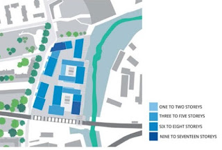
Scroll on a year and the revised plans (below) show that the heights proposed range from 'one to two storeys' to 'nine to seventeen storeys' although the information provided on the exhibition boards seems rather deliberately vague, and for some reason (no doubt to justify the height of the main tower) includes the blocks on Kent Wharf next door.


It's not easy to distinguish the difference in heights from the diagram above - if they'd chosen different colours rather than different hues of blue to differentiate the buildings, it would have been a lot easier, and of course the cynic in me thinks that was probably the reason behind the choice. And having one category ranging across potentially eight storeys, in particular since it only applies to two buildings, one of which is not even part of the development, muddies the water even more. 

Who are the 'communications' experts who put together these public consultation events? Since they are being paid by the developers, I shouldn't really be surprised that they seem more adept at creating smokescreens than at communicating basic facts to the general public.


What's all this about, for example? Why would the public care about how you intend to label the different parts of your development? What is a 'Victorian' wharf building in any case? What characteristics does it have and is it anything more than a vague aspiration at this point? Looking at the first image in the post there's nothing distinctly different about these buildings that I can see, frankly this diagram is irrelevant.

But I digress. Here's a few renderings from the 'information' boards for anyone else who missed it.


View from the Greenwich side of the creek, with the railway viaduct shown on the left hand side. Original plans were to open up routes through the railway viaduct, and although that's not explicit in the new details, the renderings suggest that it's still part of the masterplan.


Full east elevation - the white buildings on the right are Kent Wharf; an idea of the tower height on the left can be gained from the presence of the railway viaduct on the far left.


Above is a view from within the development itself, looking south towards the railway viaduct (on a street parallel to Creekside).


Oh look, green spaces! But not for the general public, only for the residents. These will be at 'podium' level, between the housing blocks. 


The renderings include an (almost) separate building for Cockpit Arts, whose current home on Creekside will be demolished to accommodate the development. I assume that they negotiating hard for favourable terms on the final scheme - having an independent building which ensures Cockpit Arts can continue its existing work in Deptford is essential. Presumably they are also in discussions to ensure that any impact on their designer-makers during the rebuild and relocation is minimised.


Of course it's all aspirational at this stage, but I was particularly taken by the level of aspiration needed to envisage the 'wonderful sunny aspect' that this new public realm is expected to have. 
The developers say that they are going to create a new public space 'in the proximity of the historic Normandy Dock inlet' which will have a cafe and outdoor seating. 

Looks quite attractive on the rendering, but in reality it is an east-facing strip of land which will only get direct sunshine for a short time in the morning, being overshadowed by the railway viaduct on the south side. Even its morning light could be threatened if/when Greenwich agrees to develop the land on the other side of the creek, no doubt with more of the high-density type of blocks that are already built on sections of the waterfront that have already been developed. And at the bottom of a seventeen-storey block it's likely to be pretty breezy. 

Sunday, 22 January 2017

More proposals for Creekside redevelopment - public exhibition

As any Deptfordian knows there is plenty of redevelopment already happening in the Creekside conservation area with Faircharm being a major part of the ongoing changes.

Now land at the other end of Creekside is being put forward for redevelopment with a public exhibition planned for Wednesday and Thursday this week. Publicity has been quite scant so I thought I'd share it here for those interested in finding out more.


The exhibition will be showing plans for 'an exciting development proposal' for these two bits of land behind and across the road from the Birds Nest Pub. It includes some of the land to the side of the Birds Nest, where the former pizza bus, (and now also former Wunderlust) are located; the yard behind the pub, some of which is under the DLR viaduct, and the old Medina building across the road at number 3.

John Cierach has teamed up with some new mates who have form in creating shipping-container pop-up developments such as Artworks at Elephant & Castle, so expect to see something along those lines on the plans. The site behind the Birds Nest in particular is limited by the presence of the DLR, with restrictions on how high and close to the piers any buildings - temporary or permanent - can be placed.

But what of Deptford Creek's boating community? There are quite a few residential boats with permanent moorings on this section of the water, and the presence of this community is one of the things that contributes to the unique nature of the Creek's conservation status.

When development comes along it's often these parts of community that suffer the harshest penalties or are under greatest pressure to move on and allow a sanitised, characterless environment to be created. The land could certainly be used more productively than it is now, but I want to know what the landowners intend to do to protect and enhance conditions for long-term residents of the creek.

Public Exhibition:
Wednesday 25th January 12-8pm
Thursday 26th January 10-6pm
3 Creekside, SE8 5SA

Sunday, 23 October 2016

Deptford carriage ramp now open - most of the way

The public realm on the old carriage ramp in front of the Deptford Project was finally unveiled last week - give or take a bit of snagging - and I was keen to explore and see what I thought about it. We've had a preview of what to expect ever since the area outside the station entrance was open to the public, with bins added after a fair bit of moaning about litter levels by the new businesses and yours truly.


It seems the litter problem is still not fully resolved - all three of the bins at ground level were full to overflowing on the first Saturday morning with presumably no prospect of them being emptied ahead of the busiest day for local businesses. Added to that when I did my rounds it seemed some of the new occupants were not fully buying-in to the clean and tidy theme of the forecourt.


Other than the three bins already mentioned - two on the approach to the station and one around the back of the new route, halfway along the carriage-ramp units - bins are notably absent from the whole of the remaining public realm. Either that's going to have to be resolved promptly, or it's going to need daily sweeping.


Currently the route through to the market is blocked off - no obvious reason why as the anti-cycling barriers are already in place and it all looks like it should be finished. 


There's not much greenery at the lower level aside from the planting right outside the station, and this pocket-handkerchief-sized bed seems a little out of place tucked alongside the extension to the back of St Paul's House. 


The two smallest arches of the ramp are open to provide access through to Octavius Street, although one of them is currently occupied by a plastic portaloo, presumably because the facilities that were promised for tenants of the units are yet to be finished.


Approaching from the high street along the ramp you get a good view across Douglas Square which has the potential to be a great people-watching spot when the market is on - and perhaps for observing the street drinker shenanigans and kids on bikes when it's not. 


Further up the ramp there's quite a few seats for those wanting somewhere to eat their lunch or drink a can of pop or something stronger. Sadly none of them are located in the best place for views.  There's two seats at the lower end that face out across the new public realm towards the extension on the back of St Paul's House, but the remainder all face away from the action, pointing directly at the new block itself. I'm somewhat puzzled as to the reason for this, perhaps it's more about 'managing' the use of this space rather than giving visitors a good view. 


Planters are made with weathering steel which means that they match nicely with the wooden benches. A couple of them have these huge hydrants sticking out of them which look totally out of place and rather ruin any effort to have everything matching and harmonious. I guess the landscape architects didn't have any say on this one, they just had to incorporate whatever the safety engineers specified.


The paving of the public realm is generally pretty good quality and the materials chosen look good. I'm hoping this will last beyond the first year or so before developing sunken potholes from bad construction or getting stained beyond recognition as a result of poor maintenance, like the stuff on the high street.

However it's unlikely to suffer wear and tear any time soon as there's currently little purpose for anyone to use the ramp. None of the commercial units at the upper ramp level is open yet - and with only one future tenant officially announced so far it seems like it could be a while before this changes.


You can't even use the ramp for its original purpose - to get to the station platform - because the ugly gates are firmly locked and there's been no attempt to maintain the top of the ramp in any case.

I seem to recall that the gates won't be open for public use until someone (presumably the developer) coughs up to have Oyster card readers installed. A ticket machine at the upper platform level would also be sensible, given that there's only one, alongside a ticket office with some of the shortest opening hours in the London area; apparently Southeastern is rolling out a whole load of new ticket machines but as yet there's no word whether that includes a second machine for Deptford.

Perhaps if tenants are found for the commercial units they'll be able to do some agitating as regards the access arrangements; until then, the ramp will remain something of a white elephant.


My only major bugbear about the quality of the final result is the disappointingly poor job that's been done on St Paul's House. The cheap replacement windows don't suit the rest of the building at all, and  stick out like a sore thumb alongside the elegant stone details of the lintels and door frames. It's difficult to appreciate the finer qualities of what could have been a simple and aesthetically-pleasing building when your eye is constantly distracted by these squat, ugly white frames. 


When so much care has obviously gone into detailing the public realm and the shop units in the carriage ramp, including designing bespoke street furniture to suit, it's sad that this level of quality does not extend to the buildings themselves.


There's still some snagging to be done, however, and I hope it is not going to be forgotten about. For example, the weathering steel of the bollards at the south entrance are looking a little, er, weathered, not to mention giving the impression of having fallen foul of the Deptford High Street Sunday Driving Fuckwittery. 


It would not surprise me - they do look a little insubstantial in this picture, and I'm sure it won't be long before at least one takes a bow courtesy of poor manoeuvres by UPS/Yodel/Iceland etc.


The boundary between the two different public realms is also quite clear here - the new market yard on the left, the 'traditional' high street paving on the right. Stand by for an update in six months or so...

Tuesday, 27 September 2016

Tidemill School & Amersham Vale redevelopments go to committee

Contentious plans to redevelop the old Tidemill School, gardens and adjacent housing on Reginald Road are due to go before Lewisham's strategic planning committee this Thursday 29th at the civic suite in Catford. Objectors will be present at the meeting both outside the building, where they intend to stage a peaceful protest, and inside where they will speak out against the plans and ask for the decision to be deferred.

At the same meeting the committee will consider plans for the associated development at Amersham Vale, on the site of the former Deptford Green School.

I've written about Tidemill before, causing a bit of a hoo-hah by revealing that the claims the council was making for the number of social/affordable housing units the development would deliver were overstated.


The council responded with a statement which you can read at the bottom of the original post, but my point is still valid. The current application for Tidemill is for 209 units; 175 private and just 34 'affordable', not the 78 that the council is trumpeting. The mix that the council is shouting about will only happen if the developer manages to access some mysterious, unspecified 'grant' funding which will subsidise it.

As the committee report states: 'The delivery of this uplift in affordable units is dependent on grant funding being secured by the applicant.' 

While the agreement commits the developer to make 'reasonable endeavours' to secure this unspecified funding, I am sure there are many circumstances beyond the developer's control that could derail the process. It's great to be optimistic but the council's statement that this development 'will provide' 37% affordable housing looks a little threadbare.

There have been a great many objections to the redevelopment plans, including anger at the loss of the green space of the former school grounds; objections to the height, proximity and overlooking/overshadowing impact the new blocks will have on existing housing such as Frankham House and Princess Louise Building; complaints about the lack of consultation from residents of the Reginald Road housing whose block is to be demolished; objections to the creation of gated public space; concern about the demolition of the caretakers house (the smaller building next to the school) and so on.

Some of these objections have been addressed, with the revised application showing amendments to certain blocks to reduce the proximity to existing buildings, and some of the overlooking issues. But objectors say that loss of light and overshadowing is still a major issue.


The loss of the gardens will mean quite a significant habitat reduction in the centre of Deptford. While we have plenty of public space, much of it is hard landscaping with trees, which is of limited interest to wildlife. The open space that will replace the Tidemill garden will also feature a lot of hard landscaping and a few manicured lawns - a pitiful substitute for the existing sprawl of green.


Over at the Amersham Vale site it's a similar story in terms of affordable housing. The proposed development will create 120 flats in blocks of up to five storeys high. Of these 120, only 19 will be for shared ownership/social rent - again the council is banking on the developer being able to achieve grant funding to subsidise additional 'affordable' units and improve this ratio from 16% to 32%. If the grant is not forthcoming, the ratio will remain pisspoor.


The proposed buildings take up half the site - the remainder now being occupied by the newly-built Charlottenburg Park, itself intended to compensate for the part of Fordham Park that was annexed for outdoor space for the relocated Deptford Green School.


As the officers report points out, the arrangement of the blocks is sufficiently cramped/awkward that some of the new units are overshadowed by their neighbours, and four of them will not receive any direct sunlight in the winter. There is also one living-room window that will not receive the required level of daylight - let's hope the resident is a night worker.

With these two developments on the table and scrutiny of Lewisham's planning process currently rather keen, it will be interesting to see how the meeting on Thursday pans out. I doubt it will be dull, so if you are keen to find out more about how the planning process works without having to stick pins in your eyes to keep yourself awake, this is probably the meeting to go to.